| Main page |
|
|
|
|
|
|
| Download ssCAD_Trial 2.0 |

|
| Donate project ssCAD 2.0 |
|
The use of this software product is governed by the license agreement, which is displayed during installation or included in the package. If after reading the text of the agreement you do not agree to its terms, you can return or destroy the software product in accordance with the procedure established in the agreement. |
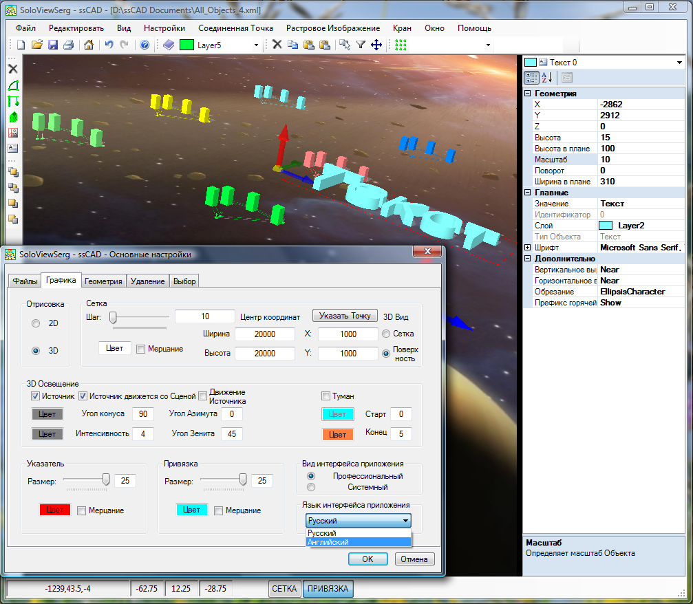

Version 2.0:
Added support for multiple user interface languages:
- Russian;
- English;
The switch for the user interface languages is located on the tab 'Graphics' in window 'Main options'.
Fixed some runtime and performance bugs;
Support OS Windows 8.
Support OS Windows 10.
Shareware license;
System requirements: Microsoft .NET Framework 2.0 and higher.
ssCAD - The automatic design tool is an object vector graphics editor with a multi-window MDI interface, 2D and 3D views of each drawing.
The main menu is duplicated by floating control panels. Their new location is fixed by the command
![]() 'Save Workspace'.
'Save Workspace'.
Drawings are saved in XML format( in the next version the format will be brought to the standard OpenXML - DrawingML).
The properties window allows you to view and edit the properties of selected objects. And also select one object or all from the selected.
Using the drawing context menu, you can:
'Rendering' change its current representation (2D or 3D);
'Zoom' change drawing scale;
![]() 'Object properties' show/hide properties window;
'Object properties' show/hide properties window;
![]() 'Main options' open application settings window;
'Main options' open application settings window;
'Cancel' cancel active command.
On the bottom control panel are located:
pointers:
current coordinates;
rotation angles around X, Y, Z axes respectively;
buttons:
'GRID' show/hide grid;
'SNAP' enable/disable snapping (to grid nodes and objects).
A more detailed description is on the page ssCAD, where you can download full-featured trial version.
Full documentation is under development. For any questions, please contact mail@soloviewserg.ru.
|
|
|
|
| Download ssCivilUtilites 2.2 |


 profile view")


AutoCAD Civil 3D Styles and Labels 2.1 allow to obtain a dynamic display of the alignment plan, profile view, cross sections as close as possible to Russian standards( road and rail), at various stages of design - from pre-design studies and feasibility studies to design and working documentation( GOST R 21.1701-97, GOST R 21.1702-96).
File AutoCAD Civil 3D Russian (Metric) by SVS v2.1.dwt is a template file from The Russian adaptation package, extended by AutoCAD Civil 3D Styles and Labels 2.1.
AutoCAD Civil 3D Styles and Labels these are the profile view data bands Slope/Length, Slope/Vertical curve without promille sign( i.e. by GOST), custom sizes alignment labels which is not dependent on the drawing scale, data bands and labels sets for render Auto and Rail profile views( profiles), sample lines, cross sections views( cross sections( cross sections profiles)).
A more detailed description of styles is on the page AutoCAD Civil 3D Styles and Labels, and here their can be downloaded as part of the ssCivilUtilites 2.2( The downloadable version of the product contains all the necessary components( including AutoCAD Civil 3D Styles and Labels 2.1( FREE)), and the license with unlimited expiration date).
|
|
|
|
|
|
|
|

|
| Download ssCivilUtilites 2.2 |
|
|
| Donate project ssCivilUtilites 2.2 |
|
The use of this software product is governed by the license agreement, which is displayed during installation or included in the package. If after reading the text of the agreement you do not agree to its terms, you can return or destroy the software product in accordance with the procedure established in the agreement. |


")


Update 2.2:
Implemented support AutoCAD Civil 3D 2023;
Added rendering by GOST 21.204-93 SPDS of Artificial Structures conventional signs and descriptions at plane and profile.
Update 2.1:
Implemented support AutoCAD Civil 3D 2015;
Optimized output of labels of working, existing, project elevations and distances(Rail/Auto) at profile view with automatic thinning(Rail/Auto), and namely:
Labels of working, existing, project elevations and distances at Finished Ground PVI have the highest status according to the thinning criterion, i.e. they are not thinned;
Insert of distance labels by Finished Ground PVI depends on the choice of the parameter 'Finished Ground PVI Type Local Extremum Area Index';
Fixed definition error of picket of Artificial Structures when you open the application window;
The limitation of the FREE license has been extended ( downloadable version ssCivilUtilites 2.2 contains a license limited to the length of the alignment no more than 100 000 meters);
Update 2.0:
Implemented support AutoCAD Civil 3D 2014;
Optimized output of Main Site Broadening(Rail);
Update 1.9:
Implemented support AutoCAD Civil 3D 2013;
The product received a new installer with a choice of version AutoCAD Civil 3D to install/uninstall the application ssCivilUtilites 2.2;
The limitation of the FREE license has been extended ( downloadable version ssCivilUtilites 2.2 contains a license limited to the length of the alignment no more than 10 000 meters);
The downloadable version of the product includes AutoCAD Civil 3D Styles and Labels 2.1( FREE);
Fixed selection error of Artificial Structures;
Fixed runtime and performance issues;
Known bugs of current version:
Failed to add user interface: Button with the name CivilUtilites exists on the panel;
Solution: run AutoCAD Civil 3D with administrator rights (Administrator rights are required to add a user interface once).
System requirements: AutoCAD Civil 3D or to draw the slopes hatch only AutoCAD Civil 3D as AutoCAD( current release supports R2009, R2010, R2011, R2012, R2013, R2014, R2015, R2016, R2017, R2018, R2019, R2020, R2021, R2022 и R2023), MS Excel for export/import data( current release supports R2016, R2013, R2010, R2007 и R2003)
ssCivilUtilites - The set of applications for AutoCAD Civil 3D allows to automate the drafting of drawings by Russian standards (road and rail, at various stages of design - from pre-design study and feasibility study to design and working documentation( GOST R 21.1701-97, GOST R 21.1702-96)), to obtain various bills of linear objects:
insert labels of working, existing, project elevations and distances (Rail/Auto) on the profile view ( taking into account 10 criteria, including automatic thinning(Rail/Auto));
import bill of volume data;
insert labels of volume data on the profile view;
insert data band of profile view(Rail/Auto)( abridged and detailed);
add/remove objects crosses the alignment(Rail/Auto);
export/import bill of objects crosses the alignment(Rail/Auto);
insert scheme plan of the alignment with crossing objects (Rail/Auto) on the profile view;
get bill of the alignment additional parameters;
get bill of the alignment elements (Form 2 GOST R 21.1702-96);
get bill of the alignment rotation angles, lines, curves, spirals;
get bill of the alignment vertical visibility;
get bill of design distances from the axis, elevations, slopes, coordinates (a special case - bill of the top design cross sections);
add/edit/remove labels of artificial structures on the plan and profile view;
export/import bill of artificial structures;
insert labels of artificial structures on the plan and profile view;
As well as to draw by Russian standards:
hatching slope( Unlimited license);
the distance from the alignment to the boundary labels(ROW);
main site broadening (Rail);
To insert most labels, you must specify an alignment, profile view, land profile, and project profile. The choice can be made in the drop-down lists at the top of the application window or by clicking on the appropriate button ![]() .
.
All labels are inserted:
with a given text height;
with a given text style;
to a specified layer (separate for each label type) that you can select or create;
with color 'ByLayer';
with line type 'ByLayer';
with line weight 'ByLayer';
with a specified offset (separate for each label type);
with specified precision (separate for each label type);
The labels and/or bills selected on the current page are inserted after clicking the button 'Insert'( In version ssCivilUtilites 2.2 implemented bills insert only in Model Space, besides Bill of the top design cross sections, which is also outputted in MS Excel). Then the program window is closed with saving all the last changes of parameters.
A new layer is created when the label layer name changes.
You can use the button ![]() to delete all objects on the selected layer .
to delete all objects on the selected layer .
Below the alignment, profile view, land profile, and project profile drop-down lists and above the label type tabs, there is a switch for the user interface languages and on/off tooltips.
The data window displays the added objects( so far only Artificial Structures and Alignment cross objects) - they can be exported to/imported from MS Excel. The Volume data is also displayed and can be imported from MS Excel.
A more detailed description is on the page ssCivilUtilites, and here can be download evaluation version. The downloadable version of the product contains all the necessary components( including AutoCAD Civil 3D Styles and Labels 2.1( FREE), contains a license with unlimited expiration date).
Full documentation is under development. For any questions, please contact mail@soloviewserg.ru.
Autodesk and AutoCAD are registered trademarks of Autodesk, Inc. in the US and other countries. ssCivilUtilites 2.2 is a standalone product and does not receive advice, sponsorship or support from Autodesk, Inc., and/or its affiliates and/or subsidiaries.
|
|
|
|
|
|
|
|
| Download ssImageInserter 2.2 |
|
|
| Donate project ssImageInserter 2.2 |
|
The use of this software product is governed by the license agreement, which is displayed during installation or included in the package. If after reading the text of the agreement you do not agree to its terms, you can return or destroy the software product in accordance with the procedure established in the agreement. |


Update 2.2:
Implemented support AutoCAD Civil 3D 2023;
The product received a new installer with a choice of version AutoCAD Civil 3D to install/uninstall the application ssImageInserter 2.2;
The limitation of the FREE license has been extended ( downloadable version ssImageInserter 2.2 contains a license limited to a maximum of 100 raster images);
Improved sorting of rows by values in any column from the list of raster image source coordinates data ( performed by clicking the column header);
Current version known bugs:
Error adding user interface: Button with name ImageInserter exists on the panel;
Solution: run AutoCAD Civil 3D with administrator rights ( administrator Rights are required to add the user interface once).
System requirements: AutoCAD Civil 3D or AutoCAD Civil 3D as AutoCAD( this release supports R2009, R2010, R2011, R2012, R2013, R2014, R2015, R2016, R2017, R2018, R2019, R2020, R2021, R2022 and R2023).
ssImageInserter - Application in environment AutoCAD allows you to automate batch processing of inserting raster images into specified coordinates:
Search - search for raster images and reading from files the original coordinates data;
Edit - visual editing of source coordinate data;
Write - saving to files original coordinates data;
Insert - batch insert the raster images at the given coordinates;
For read/edit/save the raster images source coordinates data is nessesery to specify the path to the folder, the file extension for raster image, file format data of the source coordinates and, in the case of Own XML Format(*.xml), corner coordinate tag names. All of the above options, except for the folder path, have default values.
Filling the data list of the source coordinates of raster images is populated after clicking the button 'Search'.
To display the border rectangle and corner vertices, simply select a raster image from the list. The corner vertex is displayed when you select its coordinate in the corresponding column of the list.
Change of data of source coordinates of raster images occurs after pressing of buttons
![]() 'Up',
'Up',
![]() 'Right',
'Right',
![]() 'Down',
'Down',
![]() 'Left'
'Left'
or optionally, if you edit one coordinate of the corner vertex after changing its value in the text box 'Selected in the raster image source coordinate data list'.
To save the changes made to the raster images source coordinates data you must select Write immediately or press the button 'Write all'.
Raster images and labels are inserted after the button is clicked 'Insert'. Then the program window is closed with saving all the last changes of parameters.
New named layers are created when you insert them - RasterImages and RasterImagesText.
In the right part of the application window there is a switch of user interface languages and on/off prompts.
A more detailed description is on the page ssImageInserter, and here can be download evaluation version. The downloadable version of the product contains all the necessary components (contains a license unlimited by the expiration date).
Full documentation is under development. For any questions, please contact mail@soloviewserg.ru.
Autodesk and AutoCAD are registered trademarks of Autodesk, Inc. in the US and other countries. ssImageInserter 2.2 is a standalone product and does not receive advice, sponsorship or support from Autodesk, Inc., and/or its affiliates and/or subsidiaries.
|
|
|
|
|
|
|
|
| Download ssRUtilites 3.0 |
|
|
| Donate project ssRUtilites 3.0 |
|
The use of this software product is governed by the license agreement, which is displayed during installation or included in the package. If after reading the text of the agreement you do not agree to its terms, you can return or destroy the software product in accordance with the procedure established in the agreement. |

, column header")
, column header")
 of rows by any column (generic) (for example by types)")


Update 3.0:
Implemented support Revit 2023;
System requirements: Revit (this release supports R2017, R2018, R2019, R2020, R2021, R2022 and R2023. On request support R2012, R2013, R2014, R2015 and R2016).
ssRUtilites - The set of utilities in the environment Revit allows you to automate the development of drawings according to Russian standards, customize any view and export the BOM tables, manage asynchronous backup of all open files and user name in the current Revit session.
This is the set of utilities for Revit users, design engineers, GOST drawing developers.
The application significantly reduces the time of analysis, development and design (localization of presentation) of project data in Revit to Russian standards, increases the manageability of collaboration in Revit.
Standards supported:
GOST R 21.1101-2013;
BS 1192:2007.
A more detailed description is on the page ssRUtilites, and here can be download full version. The downloadable version of the product contains all the necessary components (contains a license unlimited by the expiration date).
The product is installed/removed by copying/deleting in the folder "C:\ProgramData\Autodesk\Revit\Addins\...\"
Full documentation is under development. For any questions, please contact mail@soloviewserg.ru.
Autodesk and AutoCAD are registered trademarks of Autodesk, Inc. in the US and other countries. ssRUtilites 3.0 is a standalone product and does not receive advice, sponsorship or support from Autodesk, Inc., and/or its affiliates and / or subsidiaries.
Publisher Privacy Policy
1. The app collects data about execution difficulties by sending an email only with the end user's consent. Impersonalized technical .Net data about difficulties is used to improve the app. No private information is sent;
2. The app does not share this data with any third parties;
3. Publisher's data is stored in storage and deleted if necessary;
4. End users can choose not to send data about difficulties and/or request deletion of their data by send the corresponding request to the publisher - mail@soloviewserg.ru;
| Copyright © 2008 - 2024 |